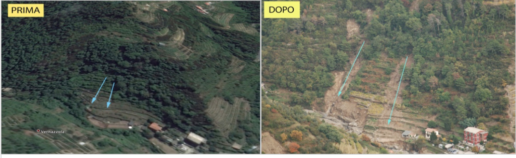
The survey carried out in November 2011 had the aim of studying the relationship between terracing and hydrogeological instability in the Cinque Terre area, which was the subject of an environmental disaster that occurred on 25 October 2011 following intense rainfall which, in about 6 hours, they poured 542 mm of rain into the territory of the provinces of La Spezia and Massa Carrara, originating landslides and landslides with damage to people and property.
The analysis material used concerns a film made by a mobile camera and about 500 photographic shots taken on 2 November 2011, from a helicopter flying in the Vernazza – Monterosso (SP) area. The digital files of the images show the geographic coordinates of the helicopter at the time of shooting, which allowed the majority of the landslides recorded to be geographically localized, using Google Earth. A series of cards were therefore created which show the location of the event, the photo shoot, the related Google Earth image (reference year 2006) and a photo-interpretation of the current class of land cover and use. 37 classification forms have been created and refer to 88 landslides of various magnitudes. Each landslide event was identified with a first visual interpretation of the material and classified. Subsequently, for each disaster event, a reclassification legend was constructed based on the uses of the land on which the event occurred, distinguishing landslide bodies and detachment niches.
The analysis of the collected data showed an evident and statistically significant relationship between crop abandonment and landslides. Out of 88 cases (100%) only in 7 of them (7.95%) no traces of abandonment were found. Of these 7 cases, 5 are attributable to areas with ongoing cultivation and 2 to areas in which a recent removal of the tree cover is noted.
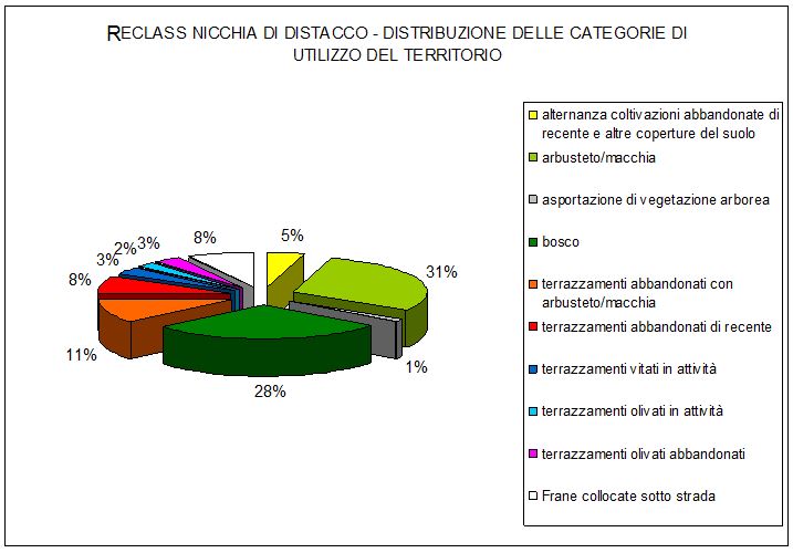
Graph 1 uses of the land in which the detachment niches originated
|
RECLASS REMOVAL NICHE |
Total |
% |
|
alternating recently abandoned crops and other soil covers |
4 |
4,55 |
|
shrub / scrub |
26 |
29,55 |
|
removal of tree vegetation |
1 |
1,14 |
|
Woods |
25 |
28,41 |
|
abandoned terraces with shrub / scrub |
10 |
11,36 |
|
recently abandoned terraces |
7 |
7,95 |
|
terraced vineyards in activity |
3 |
3,41 |
|
terraced olive groves in activity |
2 |
2,27 |
|
abandoned olive terraces |
3 |
3,41 |
|
Landslides located under the road |
7 |
7,95 |
|
Total forest categories |
|
57,95 |
|
Total categories of abandoned terraced crops |
|
27,27 |
|
Total |
88 |
100 |
|
CHROMATIC LEGEND: |
|
|
|
Categories related to abandoned crops |
|
|
|
Categories relating to forest areas |
|
|
|
Other categories |
|
The research was presented at Florens 2012 and is published in the relative volume
[gview file=”https://www.horizonspinoff.com/wp-content/uploads/2015/01/Cinque-Terre.pdf”]